Your Neighbourhood
NEW TO THE AREA? Scroll down to find our New Neighbours Kit
You don’t have to be best friends, but are you good neighbours?
RUKI’s Neighbourhoods Project slogan recognises that, when disaster strikes it is frequently our neighbours who provide us with the urgent support we need. Often well before emergency services can reach us and then, well after they have gone.
The community-led project is supporting 12 neighbourhoods from Mount Burrell to Mt Warning Road to build our capacity to support each other. It’s not just about connecting in the midst of or after a disaster: it’s about sharing information, skills, resources and support at anytime.
Each neighbourhood has a ‘Neighbourhood Leader‘ and also ‘Pod‘ or “Street Leaders‘.
Every neighbourhood will have its own way of doing things (this project is community-led, not about telling people how to do things).
Generally your pod/street/neighbourhood leaders can help keep their neighbours informed about ways to check-in and communicate within your neighbourhood in an emergency, activities and get-togethers that might be happening, opportunities to learn new skills and more.

Why are we doing this?
The first and most important reason is that a community formed through kindness is a wonderful place to live.
We believe, this will help to further strengthen our neighbourhoods so we can become more connected in good times and bad, and be better prepared and confident to look after ourselves in times of need.
It’s been a tough few years with fires, pandemic and floods. Research shows that connection and participation within and between communities affected by disaster strongly influences recovery. Disasters can bring communities together, but also compromise people’s well-being, particularly mental health. Social ties with family, friends and neighbours really matter in supporting recovery.
Basically, we hope to become a better prepared and resilient community, well equipped and confident to look after ourselves.
New to the Area ?

Image: Photo by Erda Estremera on Unsplash
Some of our local volunteers have put together a new residents ‘kit’ to share some useful information about living in the Greater Uki area.
We invite you to share this with new neighbours who move in near you. There’s a space to add your neighbourhood leader’s contact details and you may also want to add your own contact details but that’s entirely up to you.
Neighbourhood Groups
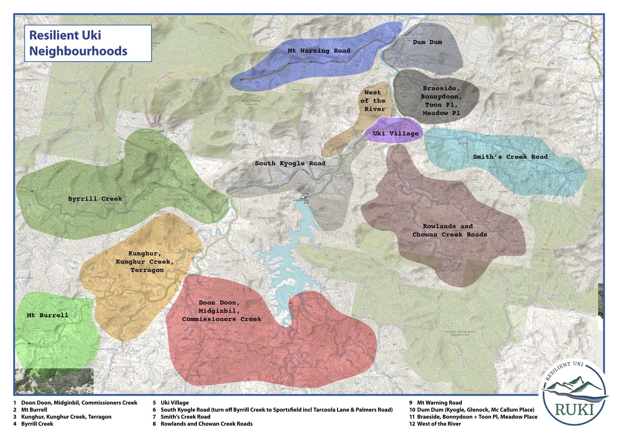
We have 12 Neighbourhoods in our area, which are each made up of a number of Pods.
Find out which neighbourhood you’re in and who the key people in your neighbourhood and your smaller neighbourhood pod are.
You don’t need to commit to anything … you can be as involved or uninvolved as you wish but at the very least it’s great to know who’s in your street or pod in case you ever need to call on each other in a disaster.
Find Your Neighbourhood
The Greater Uki district is compiled of 12 ‘Neighbourhood groups’.
They are:
1. Doon Doon, Midginbil, Commissioners Creek
2. Mount Burrell
3. Byrrill Creek
4. Kunghur and Kunghur Creek
5. Terragon to Uki
6. Uki Village
7. Rowlands and Chowan Creek Roads
8. Smiths Creek Road
9. Meadow Place
10. Braeside Drive, Bonnydoon Road, Toon Place and Kyogle Road
11. Dum Dum
12. Mt Warning Road
Contact us at secretary [at] resilientuki.org (substitute [at] with the @ symbol) if you’d like to be put in touch with your Neighbourhood Leader.
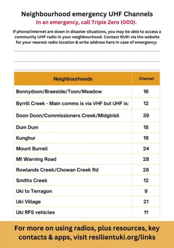
Here’s a quick guide to our Greater Uki UHF radio channels in an emergency (when mainstream comms are down). Find out more about our Communications efforts, here.
Find Your Pod
It’s up to each neighbourhood how many pods they have.
Once you know your neighbourhood, please contact your Neighbourhood Leader to find out if there are pods in your area.
FOR LIFE THREATENING EMERGENCIES CALL 000.
FOR EMERGENCY HELP IN FLOODS AND STORMS CALL THE SES NSW ON 132 500
Maps
 Maps are an important tool for The Neighbourhoods Project.
It allows neighbourhood leaders and pod leaders to have a clear picture of their neighbourhood and pod boundaries, and to locate properties/ households, geographic points of interest, e.g. landslides, places of flooding, access and assembly points, fire trails, etc.
The 12 Neighbourhood areas, extending along Kyogle Road from the first Nimbin turn off in the south west to the Mount Warning Road in the north east, and including the valleys and roads intersecting with Kyogle Road.
Each of the Neighbourhood areas is made up of pods.
How the pod divisions are made is up to the leaders of each Neighbourhood area. Although a manageable pod size is around 10 – 12 properties.
Neighbourhood area representatives will be provided with interim maps of their area for them to draw a proposed layout of their pods within their area.
These maps have been temporarily prepared from the 1:25,000 topographical maps until such time as the updated Property and Contour maps are available from Tweed Shire Council. The updated maps will show aerial photographical imagery with cadastral boundaries and natural features overlaid which will make identification easier than from the topographical maps you have now.
When the layouts of the Neighbourhood Area maps are returned individual pod maps at a larger scale will eventually be produced and returned to the pod representative and used to add information that the members of that pod considers necessary for its intended function.
On the initial pod level maps, you may want to write relevant information that will support you developing a familiarity with your pod e.g. the name of the main contact/s at that address, the number of residents, plus some code letters to indicate relevant information e.g. S (survey complete) V (vulnerable) R (radio) NI (not interested) C (comms i.e. included in email group and online forum) etc.
The ultimate aim is to collate all the information collected into a master plan/map in digital format from which hard copies may be generated at a suitable scale for the purpose; for example, individual pod maps should be at a large enough scale that is easy for even non map readers to read.
Privacy of personal information needs to be taken into consideration when putting information into maps, in the same way as the survey information. Storing the maps offline and securely and limiting access is important.
For further information about maps, contact Trevor White at tredeewhite [at] hotmail.com (substitute [at] with the @ symbol)